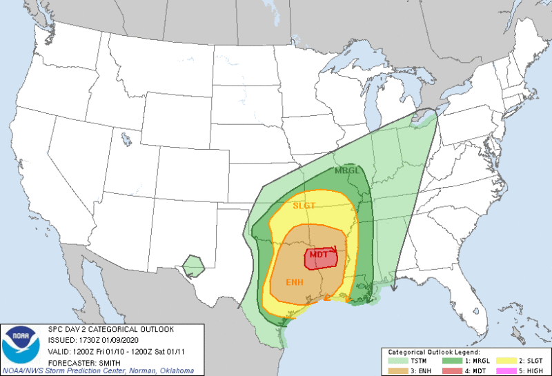
Mother Nature is opening 2020 with a bang. Severe storms are likely. Tornadoes for many are also a likelihood. Heavy snows in Missouri and heavy rains ahead and with they system will cause flash flooding and possible river flooding for many.
Lots of different elements here with Winter Storm Isaiah, but, pretty much everyone in the South is going to be affected. This is a VERY dangerous January storm, and folks in areas like Houston, Little Rock, Memphis, Nashville, Jackson, Shreveport, Birmingham, and Atlanta should be severe weather aware by Friday afternoon. OKC, KC, and St. Louis need to be on alert for flooding followed by ice, before changing to all snow. KC could see 5″-8″. By Sunday the Carolinas will be getting hit by Severe weather.
Complicating the severe weather will be, for many in the high risk area, the tornado risk will come at night. Especially Friday night to early Saturday morning.
This is a good time to check batteries. NOAA Weather radio, flashlights, portable phone chargers, etc. This storm has been predicted since Monday, and will be extremely dangerous for this time of year.
Here is the breakdown for Friday- Saturday from the NOAA Storm Prediction Center. We will update again in the morning, and as needed over the weekend.
| Friday | Area (sq. mi.) | Area Pop. | Some Larger Population Centers in Risk Area |
| MODERATE | 16,395 | 1,147,390 | Shreveport, LA…Longview, TX…Bossier City, LA…Monroe, LA…Marshall, TX… |
| ENHANCED | 118,448 | 18,864,500 | Houston, TX…Dallas, TX…Austin, TX…Fort Worth, TX…Arlington, TX… |
| SLIGHT | 126,025 | 11,209,142 | San Antonio, TX…Memphis, TN…Oklahoma City, OK…Tulsa, OK…Baton Rouge, LA… |
| MARGINAL | 132,777 | 10,446,171 | New Orleans, LA…St. Louis, MO…Corpus Christi, TX…Jackson, MS…Metairie, LA… |
1130 AM CST Thu Jan 09 2020

   Valid 101200Z - 111200Z

   ...THERE IS A MODERATE RISK OF SEVERE THUNDERSTORMS FOR PARTS OF
   NORTHEAST TEXAS...FAR SOUTHERN ARKANSAS...AND NORTHERN LOUISIANA...

   ...SUMMARY...
   Severe thunderstorms are expected by midday Friday into early
   Saturday morning from eastern Oklahoma and Texas into the lower
   Mississippi Valley. Damaging wind gusts, tornadoes and isolated
   large hail are all possible, especially across parts of eastern
   Texas into Louisiana Friday afternoon into the overnight hours.

   ...OK/TX to the lower MS Valley...
   A strong mid-level shortwave located over the southern
   Rockies/northern Mexico Friday morning will move east into OK/TX by
   early Saturday morning.  In the low levels, a surface front
   initially draped southwest-northeast across the TX Panhandle into
   the mid MS Valley will accelerate southeastward late Friday as a low
   located over the Red River Valley consolidates/develops east before
   deepening as it moves into eastern AR by the end of the period.  A
   Pacific front will gradually move east across West TX during the day
   before accelerating east after dark reaching the western Gulf/LA
   late overnight.

   Some uncertainty remains regarding early-day thunderstorms over OK
   and the magnitude of destabilization.  Some model guidance shows a
   weak low over OK during the day with cold 500 mb temperatures
   evident in forecast soundings (-18 to -20 degrees C) with surface
   dewpoints approaching 60 degrees F.  Even modest heating may lead to
   a few stronger updrafts developing before a mid-level dry slot
   overspreads southwest-central OK by mid-late afternoon.  Strong
   shear profiles would support at least some risk for hail and perhaps
   a tornado.

   Strong southerly low-level flow will enable mid 60s dewpoints to
   overspread the warm sector in TX ahead of the mid-level trough.
   Steep 700-500 mb lapse rates (due in part to the very cool 500 mb
   temperatures) coupled with the low-level moisture will result in
   moderate buoyancy developing by mid afternoon.  Thunderstorms are
   forecast to primarily develop near the Pacific front and transition
   to a forced squall line by evening as stronger mid-level height
   falls overspread central/east TX.  CAMs are indicating pre-squall
   line thunderstorms (potentially evolving into supercells) will tend
   to be limited but a supercell risk with all severe hazards is
   possible.  As the squall line organizes as it moves into eastern OK
   southward into east-central TX, the risk for damaging gusts will
   likely increase during the evening into the overnight.  Confidence
   has increased for a relatively focused corridor for damaging wind
   gusts (prompting the Moderate Risk).  The aforementioned surface low
   development/strengthening during the night coupled with very strong
   shear profiles will favor a focus for wind damage south/southeast of
   the surface low track as the squall line moves east towards the MS
   River by early morning.  A tornado risk may accompany any supercell
   able to develop in the warm sector ahead of the squall line as well
   as with the stronger/more persistent QLCS mesovortices.

   ...MAXIMUM RISK BY HAZARD...
   Tornado:  10% SIG - Enhanced
   Wind:     45% SIG - Moderate
   Hail:     15% SIG - Slight
|
||||||||||||||||||||
|
||||||||||||||||||||
|
||||||||||||||||||||


