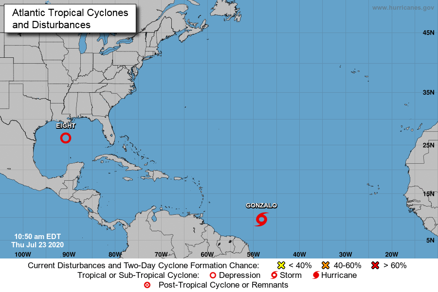
Something we will be monitoring this week is a tropical low that has started to organize over Cuba and the Bahamas. And also a Tropical Depression that has formed off the Windward Islands. We will look at TD8 first as a Tropical Storm Watch has been issued for parts of Texas.
All information below comes from the NOAA Hurricane Forecast Center:
BULLETIN
Tropical Depression Eight Advisory Number 3
NWS National Hurricane Center Miami FL AL082020
1000 AM CDT Thu Jul 23 2020
…DEPRESSION GETTING BETTER ORGANIZED OVER THE CENTRAL GULF OF
MEXICO…
…HEAVY RAINS LIKELY OVER PORTIONS OF TEXAS BY THIS WEEKEND…
SUMMARY OF 1000 AM CDT…1500 UTC…INFORMATION
———————————————–
LOCATION…26.3N 90.7W
ABOUT 380 MI…610 KM ESE OF PORT OCONNOR TEXAS
MAXIMUM SUSTAINED WINDS…35 MPH…55 KM/H
PRESENT MOVEMENT…WNW OR 285 DEGREES AT 9 MPH…15 KM/H
MINIMUM CENTRAL PRESSURE…1007 MB…29.74 INCHES
WATCHES AND WARNINGS
——————–
CHANGES WITH THIS ADVISORY:
None.
SUMMARY OF WATCHES AND WARNINGS IN EFFECT:
A Tropical Storm Watch is in effect for…
* Port Mansfield to High Island Texas
A Tropical Storm Watch means that tropical storm conditions are
possible within the watch area, generally within 48 hours.
Interests elsewhere along the Texas and Louisiana coast should
monitor the progress of this system. Tropical Storm Warnings may
be required for portions of the Watch area later today.
For storm information specific to your area, including possible
inland watches and warnings, please monitor products issued by your
local National Weather Service forecast office.
DISCUSSION AND OUTLOOK
———————-
At 1000 AM CDT (1500 UTC), the center of Tropical Depression Eight
was located near latitude 26.3 North, longitude 90.7 West. The
depression is moving toward the west-northwest near 9 mph (15 km/h),
and a west-northwestward to westward motion is expected during the
next couple of days. On the forecast track, the center of the
depression is expected to move across the northwestern Gulf of
Mexico today and Friday and make landfall along the Texas coast
on Saturday.
Maximum sustained winds are near 35 mph (55 km/h) with higher gusts.
Slow strengthening is expected, and the depression could become a
tropical storm during the next 12 to 24 hours. An Air Force
Reserve Hurricane Hunter aircraft is currently enroute to
investigate the depression.
The estimated minimum central pressure is 1007 mb (29.74 inches).
HAZARDS AFFECTING LAND
———————-
WIND: Tropical storm conditions are possible within the watch
area by Friday night.
RAINFALL: The tropical depression is expected to produce 3 to 5
inches of rain with isolated maximum totals of 8 inches through
Monday along the Gulf Coast from Louisiana to the Lower Texas Coast,
and inland through south-central Texas and the Rio Grande Valley.
This rain may result in flash flooding, rapid rises on small
streams, and isolated minor flooding across the west-central Gulf
Coast and into portions of south Texas.
SURF: Swells generated by the depression are expected to increase
and affect much of the Texas and Louisiana coasts in a day or two.
These swells are likely to cause life-threatening surf and rip
current conditions. Please consult products from your local
weather office.
NEXT ADVISORY
————-
Next intermediate advisory at 100 PM CDT.
Next complete advisory at 400 PM CDT.
Gonzalo
BULLETIN
Tropical Storm Gonzalo Advisory Number   8
NWS National Hurricane Center Miami FL       AL072020
1100 AM AST Thu Jul 23 2020

...GONZALO FACES AN UNCERTAIN FUTURE...
...BUT EXPECTED TO BEGIN AFFECTING PORTIONS OF THE WINDWARD ISLANDS
ON SATURDAY...


SUMMARY OF 1100 AM AST...1500 UTC...INFORMATION
-----------------------------------------------
LOCATION...9.6N 48.3W
ABOUT 885 MI...1425 KM E OF THE SOUTHERN WINDWARD ISLANDS
MAXIMUM SUSTAINED WINDS...65 MPH...100 KM/H
PRESENT MOVEMENT...W OR 270 DEGREES AT 14 MPH...22 KM/H
MINIMUM CENTRAL PRESSURE...997 MB...29.44 INCHES


WATCHES AND WARNINGS
--------------------
CHANGES WITH THIS ADVISORY...

None.

SUMMARY OF WATCHES AND WARNING IN EFFECT...

A Hurricane Watch is in effect for...
* Barbados
* St. Vincent and the Grenadines

A Hurricane Watch means that hurricane conditions are possible
within the watch area.  A watch is typically issued 48 hours before
the anticipated first occurrence of tropical-storm-force winds,
conditions that make outside preparations difficult or dangerous.

Interests in the Windward Islands should monitor the progress of
this system.  Additional watches or warnings will likely be
required for some of these islands later today.

For storm information specific to your area, please monitor
products issued by your national meteorological service.


DISCUSSION AND OUTLOOK
----------------------
At 1100 AM AST (1500 UTC), the center of Tropical Storm Gonzalo was
located near latitude 9.6 North, longitude 48.3 West.  Gonzalo is
moving toward the west near 14 mph (22 km/h).  A westward to
west-northwestward motion with an increase in forward speed is
expected through the weekend.  On the forecast track, the center of
Gonzalo will approach the southern Windward Islands Friday night
and move across the islands Saturday and Saturday evening.

Maximum sustained winds are near 65 mph (100 km/h) with higher
gusts.  Some strengthening is forecast during the next couple of
days, and Gonzalo could become a hurricane tonight or on Friday.

Gonzalo is a small storm, and tropical-storm-force winds extend
outward up to 35 miles (55 km) from the center.

The estimated minimum central pressure is 997 mb (29.44 inches).


HAZARDS AFFECTING LAND
----------------------
WIND:  Hurricane conditions are possible within the watch area by
Saturday afternoon, with tropical storm conditions possible by
midday Saturday.

RAINFALL:  Gonzalo is expected to produce total rain accumulations
of 2 to 5 inches, with isolated maximum amounts of 7 inches in
Barbados and the Windward Islands from Friday night through Sunday
night.  Gonzalo is also expected to produce total rain accumulations
of 1 to 2 inches in Trinidad and Tobago.  Rainfall in Barbados and
the Windward Islands could lead to life-threatening flash floods.

Key messages for Gonzalo can be found in the Tropical Cyclone
Discussion under AWIPS header MIATCDAT2 and WMO header
WTNT42 KNHC.


NEXT ADVISORY
-------------
Next intermediate advisory at 200 PM AST.
Next complete advisory at 500 PM AST.

$$
Forecaster Berg


