


Lot’s of uncertainties on strength, but, forecasters seem confident that Tropical Storm Dorian will hit Florida this weekend with at least heavy rains and gusty winds. Caution is being taken to not ignore this system and we will continue to monitor it’s development through the NWS.
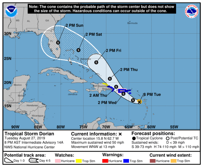
800 PM AST Tue Aug 27 2019

Corrected forecaster name

...DORIAN HEADING FOR PUERTO RICO...


SUMMARY OF 800 PM AST...0000 UTC...INFORMATION
----------------------------------------------
LOCATION...15.8N 62.7W
ABOUT 300 MI...480 KM SE OF PONCE PUERTO RICO
MAXIMUM SUSTAINED WINDS...50 MPH...85 KM/H
PRESENT MOVEMENT...WNW OR 300 DEGREES AT 13 MPH...20 KM/H
MINIMUM CENTRAL PRESSURE...1005 MB...29.68 INCHES


WATCHES AND WARNINGS
--------------------
CHANGES WITH THIS ADVISORY:

The government of the Dominican Republic has discontinued the
Hurricane Watch from Isla Saona to Samana, and discontinued the
Tropical Storm Watch from Isla Saona to Punta Palenque.

SUMMARY OF WATCHES AND WARNINGS IN EFFECT:

A Hurricane Watch is in effect for...
* Puerto Rico

A Tropical Storm Warning is in effect for...
* Puerto Rico
* Vieques
* Culebra
* U.S. Virgin Islands
* Dominican Republic from Isla Saona to Samana

A Tropical Storm Watch is in effect for...
* Dominican Republic from Samana to Puerto Plata

A Hurricane Watch means that hurricane conditions are possible
within the watch area.  A watch is typically issued 48 hours
before the anticipated first occurrence of tropical-storm-force
winds, conditions that make outside preparations difficult or
dangerous.

A Tropical Storm Warning means that tropical storm conditions are
expected somewhere within the warning area within 36 hours.

A Tropical Storm Watch means that tropical storm conditions are
possible within the watch area, generally within 48 hours.

For storm information specific to your area in the United
States, including possible inland watches and warnings, please
monitor products issued by your local National Weather Service
forecast office. For storm information specific to your area
outside of the United States, please monitor products issued by
your national meteorological service.


DISCUSSION AND OUTLOOK
----------------------
At 800 PM AST (0000 UTC), the center of Tropical Storm Dorian was
located by an Air Force Reserve Unit Hurricane Hunter aircraft near
latitude 15.8 North, longitude 62.7 West.  Dorian is moving toward
the west-northwest near 13 mph (20 km/h), and this motion is
expected to continue through tonight, followed by a turn toward the
northwest on Wednesday.  On the forecast track, the center of Dorian
will move across the northeastern Caribbean Sea tonight, pass over
or near western and central Puerto Rico on Wednesday, and move near
or just east of eastern Hispaniola Wednesday night.  On Thursday
night and Friday, the center of Dorian is forecast to move near or
to the east of the Turks and Caicos and the southeastern Bahamas.

Maximum sustained winds remain near 50 mph (85 km/h) with higher
gusts.  Slow strengthening is forecast during the next 24 hours, and
Dorian is forecast to be near hurricane strength when it approaches
Puerto Rico on Wednesday.  Some weakening is expected after Dorian
moves across the higher terrain of Puerto Rico Wednesday night.
Dorian is expected to gradually re-strengthen on Thursday and Friday
while passing near or to the east of the Turks and Caicos and
southeastern Bahamas.

Tropical-storm-force winds extend outward up to 45 miles (75 km)
from the center.

The minimum central pressure reported by the Hurricane Hunter
aircraft is 1005 mb (29.68 inches).
RAINFALL:  Dorian is expected to produce the following rainfall
accumulations:

Guadeloupe to Dominica...1 to 4 inches.
Puerto Rico and Dominican Republic...4 to 6 inches, isolated 8
inches.
Virgin Islands and Haiti...1 to 3 inches, isolated 4 inches.
Bahamas...2 to 4 inches.
Florida...3 to 5 inches, isolated 7 inches.

This rainfall may cause life-threatening flash floods.

WIND:  Tropical storm conditions are expected and hurricane
conditions are possible in Puerto Rico on Wednesday.  Tropical
storm conditions are expected in the U.S. Virgin Islands on
Wednesday.  Tropical storm conditions are expected in portions of
the Dominican Republic late Wednesday and Thursday.

SURF:  Swells generated by Dorian should gradually subside in the
Lesser Antilles tonight. Swells are expected to increase
along the southern coasts of Puerto Rico and Hispaniola on Wednesday
and they could cause life-threatening surf and rip current
conditions.  Please consult products from your local weather office.
Dry air should continue to plague Dorian for the next 24 hours or
so, resulting in only slow strengthening. Land interaction with
Puerto Rico should significantly weaken the small cyclone, thus the
intensities were lowered at 36 and 48 hours. On days 3-5, the models
continue to indicate that the upper-level flow pattern and shear
conditions should favor strengthening, especially since Dorian will
be moving over SSTs greater than 29 deg C and into a moist mid-level
environment. The dynamical models such as the GFS, UKMET, and ECMWF
are now showing more strengthening than previous runs, but still
remain well below the statistical SHIPS and LGEM intensity models,
which bring Dorian to category 1 or 2 strength by day 5. The
official intensity forecast remains a compromise between the these
two extremes, and is close to the HCCA and FSSE consensus models.
Given the large spread in the guidance, there remains lower-than-
normal confidence in the intensity forecast, especially on days 4
and 5.


