For Traffic and Airport Delays Click Here
From the NWS:
Short Range Forecast Discussion NWS Weather Prediction Center College Park MD 304 AM EST Sun Dec 22 2019 Valid 12Z Sun Dec 22 2019 – 12Z Tue Dec 24 2019 …
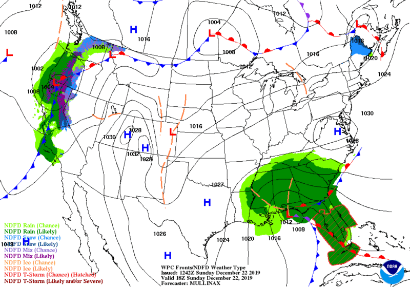
Soaking Rain and a Threat for Flash Flooding in the Southeast…
…Scattered Showers and Mountain Snow in the West..
. …Mild and Mostly Dry in the Heartland and Northeast…
A cut-off upper level low pressure system over the South Central U.S. is tapping into moisture from the Gulf of Mexico and producing periods of rain across the Deep South early this morning. As the upper level low slowly moves east later today so will its shield of rain and embedded thunderstorms. Some storms could be severe especially in South Florida late Sunday where severe storms could contain damaging winds or tornadoes.
Further north, strengthening onshore winds combined with heavy rainfall rates will lead to flooding in parts of the Southeast. The areas most at risk for flooding Sunday and Monday are the coasts of Georgia and South Carolina where rainfall totals of 3-6″ are likely with isolated totals eclipsing 7″ possible. A moderate risk for excessive rainfall has been issued for today and Monday and Flash Flood Watches are in effect for portions of these areas through Christmas Eve morning. Rain will finally taper off by Christmas Eve as the storm tracks east into the western Atlantic.
Further west, a longwave trough refuses to leave the western U.S. alone which means more showers and mountain snow today and lasting into Christmas Eve. Sunday will be wet in California on north up the Pacific Northwest coast. Winter Weather Advisories and a couple Winter Storm Warnings are in effect for most of the highest elevations of California into Sunday evening due to more impending mountain snowfall. The trough will slowly inch east and by Christmas Eve showers and mountain snow will be possible in parts of the Southwest.
Despite the active weather in the Southeast and along the West Coast, the next few days will feature tranquil conditions and mild temperatures from the Nation’s Heartland to the Northeast. Temperature anomalies, on average, of 10 to 15 degrees above normal will be common in the Northern Rockies and the Midwest on Sunday, then reaching the Ohio Valley and Northeast on Monday. While a cold frontal passage cools down parts of the Northeast on Christmas Eve, the nation’s mid-section will remain mild and dry leading up to Christmas Eve night.


