Short Range Forecast Discussion NWS Weather Prediction Center College Park MD 302 AM EST Thu Dec 26 2019 Valid 12Z Thu Dec 26 2019 – 12Z Sat Dec 28 2019 …
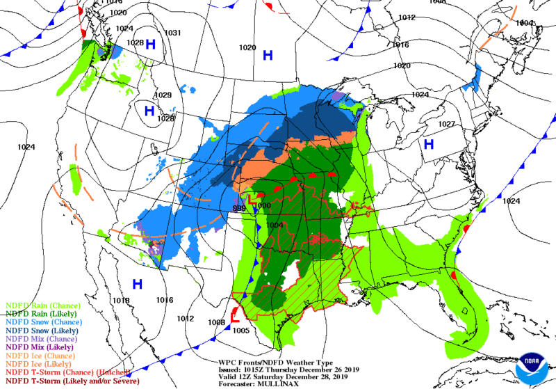
There is a Slight Risk of excessive rainfall for parts of southern California and southwest Arizona… …Southwest storm system to strengthen over the Plains this weekend… …Wintry conditions in the Upper Midwest this morning, the into New England Friday morning …
A potent storm system off the coast of southern California will continue to impact the region through Thursday with bands of heavy rain, embedded thunderstorms, and heavy mountain snow. A Slight Risk for excessive rainfall remains in place for parts of southern California and southwest Arizona where Flash Flood Watches are in effect. Localized areas of flash flooding are possible especially within bands of heavy rain where rainfall rates could reach 1 inch per hour. Heavy snow will blanket the southern California mountains with snow likely to be measured in feet in the higher elevations. Lower elevation rain and mountain snow will continue in these areas through late Thursday but drier conditions will return by Friday morning.
An upper level trough responsible for the Desert Southwest storm system on Thursday will track east through the Southwest U.S. and northern Mexico Friday and into Friday night where it will generate scattered showers and mountain snow.
Heavy snow in the southern Rockies is expected with localized amounts over a foot expected.
By Saturday morning, a new low pressure system will intensify in the Central Plains with periods of snow developing on its northern and western flanks. Snow will fall heavily at times on Saturday from the central Rockies and High Plains to the Dakotas. These regions will also deal with gusty winds that will cause drifting snow and poor visibilities. In the storm’s warm sector, showers and thunderstorms will push across the southern Plains on Saturday.
A disturbance tracking through the Upper Midwest is producing wintry precipitation and fog across the region this morning. Patchy areas of freezing fog are also possible in parts of Minnesota and Wisconsin. Drier conditions will arrive this evening as high pressure builds in from the west. Meanwhile as the storm heads northeast, its associated warm front will track through New England Friday morning leading to showers and patchy areas of freezing rain. Ice accumulations will be light but could produce slick spots for the Friday morning commute.
Extended Forecast Discussion
NWS Weather Prediction Center College Park MD
129 AM EST Thu Dec 26 2019

Valid 12Z Sun Dec 29 2019 - 12Z Thu Jan 02 2020


...Weather Highlights/Threats...

As low pressure develops and begins to deepen moves northeastward
across the Midwest/Great Lakes Sun-Mon, an area of precipitation
is expected to accompany the system.
Potentially significant accumulating snows are expected Sun-Sun night across portions of
the Upper Midwest/Great Lakes. Accumulating winter weather will
also be possible for northern New England Sun/Sun night, likely
continuing into part of Mon before changing to rain. Please see
the medium range winter weather outlook products for more details
on the winter weather threat.
 Farther south along the cold front, rain is expected across the Southeast, Appalachians, and
Mid-Atlantic regions through Sun night before the cold front moves
offshore on Mon.
Across the Pacific Northwest, as the shortwave moves onshore early next week, rain and mountain snow
are forecast
to develop across the coastal ranges and Cascades in Oregon and
Washington, potentially spreading farther inland into portions of
the northern Rockies by midweek.
As the next cutoff southern
stream system begins to interact with a northern stream trough and
approaches the central U.S. by next Tue-Wed, ample moisture from
the Gulf of Mexico is forecast to be pulled northward into the
system, with the potential for widespread showers and
thunderstorms across portions of the western/central Gulf Coast
and lower Mississippi Valley, with the potential for areas of
heavy rain. Confidence in this aspect of the forecast is a bit
below average at this time, however, given model variability with
the forward speed of the cutoff upper low.

Temperatures are forecast to be well above average across the
central and eastern U.S. on Sun ahead of the low pressure system.
High temperatures of 15 to 25 deg F above average are forecast
across portions of the Ohio Valley, central Appalachians, and
Great Lakes, with a much of the eastern third of the country at
least 10 deg F above average ahead of the cold front. Low
temperatures across these area on Sunday are forecast to be 20 to
35 deg F above average, with a number of record high minimum
temperatures likely. These warm conditions should moderate
somewhat by Mon as they shift to the Mid-Atlantic/Northeast. The
cold front forecast to arrive by Sun-Mon will bring an end to the
warm temperatures from west to east, with temperatures returning
to near seasonal norms. Meanwhile, given persistent lower heights
across the interior western U.S., highs are forecast to be 5 to 10
deg below average from the Great Basin to much of the Southwest
and portions of the Great Basin and central/southern Rockies
through much of the forecast period.


