August 8, 2019-NOAA forecasters monitoring oceanic and atmospheric patterns say conditions are now more favorable for above-normal hurricane activity since El Nino has now ended. Two named storms have formed so far this year and the peak months of the hurricane season, August through October, are now underway.
“NOAA will continue to deliver the information that the public depends on before, during and after any storms throughout the hurricane season,” said Neil Jacobs, Ph.D., acting NOAA administrator. “Armed with our next-generation satellites, sophisticated weather models, hurricane hunter aircraft, and the expertise of our forecasters, we are prepared to keep communities informed to help save lives and livelihoods.”
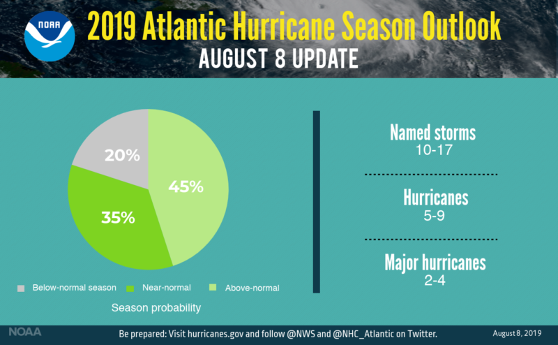
Seasonal forecasters with NOAA’s Climate Prediction Center have increased the likelihood of an above-normal Atlantic hurricane season to 45% (up from 30% from the outlook issued in May). The likelihood of near-normal activity is now at 35%, and the chance of below-normal activity has dropped to 20%.
The number of predicted storms is also greater with NOAA now expecting 10-17 named storms (winds of 39 mph or greater), of which 5-9 will become hurricanes (winds of 74 mph or greater), including 2-4 major hurricanes (winds of 111 mph or greater). This updated outlook is for the entire six-month hurricane season, which ends Nov. 30.
NOAA is also announcing today that the current El Nino in the Pacific Ocean has ended and neutral conditions have returned. “El Nino typically suppresses Atlantic hurricane activity but now that it’s gone, we could see a busier season ahead,” said Gerry Bell, Ph.D., lead seasonal hurricane forecaster at NOAA’s Climate Prediction Center. “This evolution, combined with the more conducive conditions associated with the ongoing high-activity era for Atlantic hurricanes that began in 1995, increases the likelihood of above-normal activity this year.”
On average, the Atlantic hurricane season produces 12 named storms, of which six become hurricanes, including three major hurricanes. NOAA’s hurricane season outlook is for overall seasonal activity and is not a landfall forecast. Landfalls are largely determined by short-term weather patterns, which are only predictable within about a week of a storm potentially reaching a coastline.
 “Today’s updated outlook is a reminder to be prepared,” said Pete Gaynor, acting FEMA administrator. “We urge everyone to learn more about hurricane hazards and prepare now, ahead of time, so that if state and local authorities announce evacuations in advance of a storm, you and your family will have planned where to go and what to do to stay safe.”
This week, the FEMA Ready Campaign and its federal partners released videos that show the deadly threat from tropical weather, specifically hurricane storm surge and flooding, to help emphasize the importance of following the instructions of state and local authorities in advance of a storm. The 15, 30 and 60-second video clips are available for broadcast or social media distribution and complement additional storm surge resources from NOAA.
NOAA encourages residents in communities that can be impacted by landfalling hurricanes to ensure their preparedness measures are in place now to become a more Weather-Ready Nation. Stay tuned to the National Hurricane Center for the latest about tropical storm and hurricane activity in the Atlantic.


