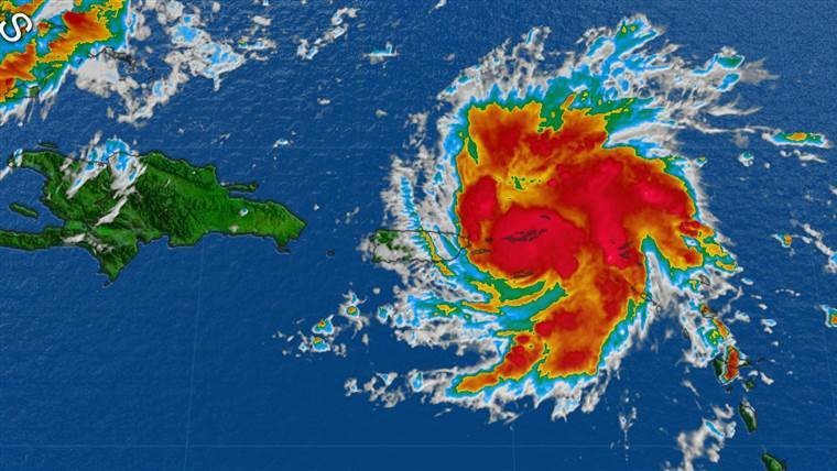
Latest from the NWS. Please note we will be updating as the storm approaches the Florida coast as often as possible. Updates will be only from the NWS . Between today and Tomorrow we will update at least every 8 hours. Beginning Friday we will work hard to keep up with updates as the come from NWS.
Live cams will be put on our site Thursday. Like us on Facebook or follow us on Instagram for the latest.
From the NWS 8/28/19 4:00 p.m. CST
Hurricane Dorian Advisory Number  18
NWS National Hurricane Center Miami FL       AL052019
500 PM AST Wed Aug 28 2019

...DORIAN GRADUALLY MOVING AWAY FROM THE NORTHEASTERN CARIBBEAN
SEA...
...EXPECTED TO BECOME A DANGEROUS HURRICANE IN THE WESTERN
ATLANTIC...


SUMMARY OF 500 PM AST...2100 UTC...INFORMATION
----------------------------------------------
LOCATION...18.8N 65.5W
ABOUT 45 MI...70 KM NW OF ST. THOMAS
MAXIMUM SUSTAINED WINDS...80 MPH...130 KM/H
PRESENT MOVEMENT...NW OR 320 DEGREES AT 14 MPH...22 KM/H
MINIMUM CENTRAL PRESSURE...997 MB...29.44 INCHES


WATCHES AND WARNINGS
--------------------
CHANGES WITH THIS ADVISORY:

None.

SUMMARY OF WATCHES AND WARNINGS IN EFFECT:

A Hurricane Warning is in effect for...
* Vieques and Culebra
* U.S. Virgin Islands
* British Virgin Islands

A Hurricane Watch is in effect for...
* Puerto Rico

A Tropical Storm Warning is in effect for...
* Puerto Rico

For storm information specific to your area in the United States,
including possible inland watches and warnings, please monitor
products issued by your local National Weather Service forecast
office. For storm information specific to your area outside of the
United States, please monitor products issued by your national
meteorological service.


DISCUSSION AND OUTLOOK
----------------------
At 500 PM AST (2100 UTC), the apparent eye of Hurricane Dorian was
located near latitude 18.8 North, longitude 65.5 West. Dorian is
moving toward the northwest near 14 mph (22 km/h). On this track,
Dorian should continue to move near or over the U.S. and British
Virgin Islands during the next several hours and then move over the
Atlantic well east of the southeastern Bahamas on Thursday and
Friday.

Maximum sustained winds have increased to near 80 mph (130 km/h)
with higher gusts.  Dorian is forecast to strengthen and become a
powerful hurricane during the next few days over the Atlantic
waters.

Hurricane-force winds extend outward up to 15 miles (30 km) from the
center and tropical-storm-force winds extend outward up to 80 miles
(130 km).

The estimated minimum central pressure is 997 mb (29.44 inches).


HAZARDS AFFECTING LAND
----------------------
RAINFALL:  Dorian is expected to produce the following rainfall
accumulations:

Northern Leeward Islands...1 to 3 inches.
Eastern Puerto Rico, the the U.S. and British Virgin Islands...4 to
6 inches, isolated 8 inches.
Western Puerto Rico and the central and northwestern Bahamas...2 to
4 inches, isolated 6 inches.
Coastal sections of the Southeast United States...4 to 8 inches,
isolated 10 inches.

This rainfall may cause life-threatening flash floods.

WIND:  Hurricane conditions are ongoing over portions of the U.S.
Virgin Islands, and could still occur over Vieques, Culebra,
and the British Virgin Islands during the next several hours. These
winds should subside tonight. Tropical storm conditions are
expected in Puerto Rico this afternoon and tonight.

Wind speeds atop and on the windward sides of hills and mountains
are often up to 30 percent stronger than the near-surface winds
indicated in this advisory, and in some elevated locations could be
even greater.

SURF:   Swells are expected to increase later today across the U.S.
and British Virgin Islands and along the southern coasts of Puerto
Rico and Hispaniola, and they could cause life-threatening surf and
rip current conditions.  Please consult products from your local
weather office.


NEXT ADVISORY
-------------
Next intermediate advisory at 800 PM AST.
Next complete advisory at 1100 PM AST.
Key Messages:

1. Dangerous winds will continue in the Virgin Islands, Culebra,
Vieques, and portions of Puerto Rico during the next few hours.
Heavy rainfall over portions of Puerto Rico and the Virgin Islands
could produce flash flooding through Thursday morning.

2. The risk of dangerous storm surge and hurricane-force winds later
this week and this weekend continues to increase in the central and
northwestern Bahamas and along the Florida east coast, although it
is too soon to determine where these hazards will occur. Residents
in these areas should ensure they have their hurricane plan in place
and not focus on the exact forecast track of Dorian's center.

3. Heavy rains are expected to occur over portions of the Bahamas,
Florida, and elsewhere in the southeastern United States later this
week and into early next week.
Satellite and earlier reconnaissance plane fixes indicate that
Dorian has been moving toward the northwest or 320 degrees at 12
kt.  The cyclone is heading toward a weakness in the Atlantic
subtropical ridge, and this northwest motion should continue for the
next 24 to 48 hours. However, after that time, all the global models
continue to build a strong ridge over the western Atlantic, and this
flow pattern should force Dorian to turn more to the west-northwest
toward Florida. All indications are that by this Labor Day weekend,
a powerful hurricane will be near or over the Florida peninsula. The
new NHC track forecast is a little bit to the south of the previous
one, given that global models have a stronger ridge to the north and
the track models show more of a westward motion.  Users are reminded
not to focus on the exact forecast track, as the average 5-day track
error is around 200 miles.


