Latest from the NWS. Updates will be only from the NWS and the NHC.
LIVE stream web cams covering Dorian and in Dorian’s path
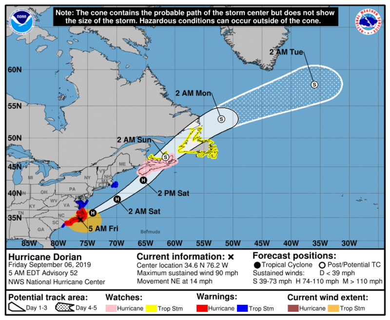
Dorian will exit into the Atlantic later today. Flooding and tornadoes are the biggest concern for the Carolinas this morning. This will be the last update we do on Dorian as it exits the South. We are monitoring a new system off the coast of Africa, but, no new threatening tropical development is expected thru the weekend.
Vote For Your Favorite College Football Tradition Here.
BULLETIN
Hurricane Dorian Advisory Number  52...Corrected
NWS National Hurricane Center Miami FL       AL052019
500 AM EDT Fri Sep 06 2019

Corrected direction to Cape Lookout

...EYE OF DORIAN PASSING JUST EAST OF CAPE LOOKOUT...
...HURRICANE-FORCE SUSTAINED WINDS OCCURRING IN THE SOUTHERN
OUTER BANKS OF NORTH CAROLINA...
DISCUSSION AND OUTLOOK
----------------------
At 500 AM EDT (0900 UTC), the center of Hurricane Dorian was located
near latitude 34.6 North, longitude 76.2 West. Dorian is moving
toward the northeast near 14 mph (22 km/h) and this general motion
with an increase in forward speed is expected through Saturday.  On
the forecast track, the center of Dorian will move near or over the
coast of North Carolina during the next several hours.  The center
should move to the southeast of extreme southeastern New England
tonight and Saturday morning, and then across Nova Scotia late
Saturday or Saturday night.

Maximum sustained winds are near 90 mph (150 km/h) with higher
gusts.  Dorian should remain a powerful hurricane as it moves near
or along the coast of North Carolina during the next several hours.
Dorian is forecast to become a post-tropical cyclone with
hurricane-force winds by Saturday night as it approaches Nova
Scotia.

Hurricane-force winds extend outward up to 45 miles (75 km) from the
center and tropical-storm-force winds extend outward up to 220 miles
(350 km).  A NOAA weather station at Cape Lookout, North Carolina,
located inside the western eyewall of Dorian has reported
sustained hurricane-force winds of 74 mph (119 km/h) and a gust to
94 mph (152 km/h).  This is equivalent to a 1-minute sustained wind
speed of 81 mph (130 km/h).  A Weatherflow station at Fort Macon
near Atlantic Beach, North Carolina, recently reported a sustained
wind of 64 mph (103 km/h) and a gust to 85 mph (137 km/h).

The estimated minimum central pressure based on data from the Air
Force Hurricane Hunters and surface observations is 956 mb (28.23
inches).


HAZARDS AFFECTING LAND
----------------------
WIND:  Hurricane conditions are spreading northward along portions
of the North Carolina coast. Tropical storm conditions are still
affecting the northern portion of the South Carolina coast.

Tropical storm conditions are expected in the Tropical Storm
Warning area in the Mid-Atlantic states later today and over
portions of extreme southeastern Massachusetts tonight or early
Saturday.

STORM SURGE:  The combination of a dangerous storm surge and the
tide will cause normally dry areas near the coast to be flooded by
rising waters moving inland from the shoreline.  The water could
reach the following heights above ground somewhere in the indicated
areas if the peak surge occurs at the time of high tide...

Surf City to Duck NC, including Pamlico and Albemarle
Sounds and the Neuse and Pamlico Rivers...4 to 7 ft
Duck NC to Poquoson VA, including Hampton Roads...2 to 4 ft

Water levels could begin to rise well in advance of the arrival of
strong winds.  The surge will be accompanied by large and
destructive waves.  Surge-related flooding depends on the how close
the center of Dorian comes to the coast, and can vary greatly over
short distances.  For information specific to your area, please see
products issued by your local National Weather Service forecast
office.

RAINFALL:  Dorian is expected to produce the following rainfall
totals through Saturday.

Northeastern North Carolina...Additional 3 to 8 inches, isolated
storm totals 15 inches.
Far southeast Virginia...3 to 8 inches.
Extreme Southeastern New England...2 to 4 inches.
Nova Scotia and Prince Edward Island...3 to 5 inches.
New Newfoundland...1 to 2 inches

This rainfall may cause life-threatening flash floods

SURF:  Large swells will affect much of the southeastern United
States coast from northern Florida through North Carolina during
the next couple of days.  These swells are likely to cause
life-threatening surf and rip current conditions. Please consult
products from your local weather office.

TORNADOES:  A few tornadoes are possible this morning across
eastern North Carolina into southeastern Virginia.
SUMMARY OF 500 AM EDT...0900 UTC...INFORMATION ---------------------------------------------- LOCATION...34.6N 76.2W ABOUT 25 MI...35 KM E OF CAPE LOOKOUT NORTH CAROLINA ABOUT 55 MI...90 KM SW OF CAPE HATTERAS NORTH CAROLINA MAXIMUM SUSTAINED WINDS...90 MPH...150 KM/H PRESENT MOVEMENT...NE OR 50 DEGREES AT 14 MPH...22 KM/H MINIMUM CENTRAL PRESSURE...956 MB...28.23 INCHES WATCHES AND WARNINGS -------------------- CHANGES WITH THIS ADVISORY: The Hurricane Warning has been replaced with a Tropical Storm Warning from South Santee River, SC to Little River Inlet. The Storm Surge Warning south of Surf City has been discontinued. SUMMARY OF WATCHES AND WARNINGS IN EFFECT: A Storm Surge Warning is in effect for... * Surf City NC to Poquoson VA * Pamlico and Albemarle Sounds * Neuse and Pamlico Rivers * Hampton Roads A Hurricane Warning is in effect for... * Little River Inlet to the North Carolina/Virginia border * Pamlico and Albemarle Sounds A Hurricane Watch is in effect for... * Nova Scotia A Tropical Storm Warning is in effect for... * South Santee River SC to Little River Inlet * North Carolina/Virginia border to Fenwick Island DE * Chesapeake Bay from Drum Point southward * Tidal Potomac south of Cobb Island * Woods Hole to Sagamore Beach MA * Nantucket and Martha's Vineyard MA A Tropical Storm Watch is in effect for... * Prince Edward Island * Magdalen Islands * Fundy National Park to Shediac. * Francois to Boat Harbour.


