


Because 2020 is so awesome, there is the possibility that we have 2 Tropical storms in the Gulf by the end of the weekend/early next week.
2 Tropical Depressions are expected to strengthen over the next 48-72 hours , and both are projected to roll into the Gulf of Mexico next week.
We will monitor and keep you updated as things develop. For now, might be a good time to check your safety kit, and enjoy the weekend. But, conditions should be monitored for change.
I will be giving a couple of LIVE updates on our Facebook page over the weekend, as I am in the path of TD14 in Mexico.
Ok here is what we know from the NHC:
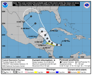
 TD 14
TD 14
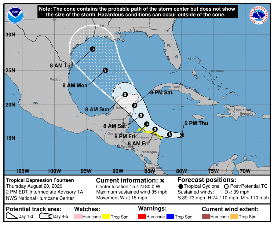
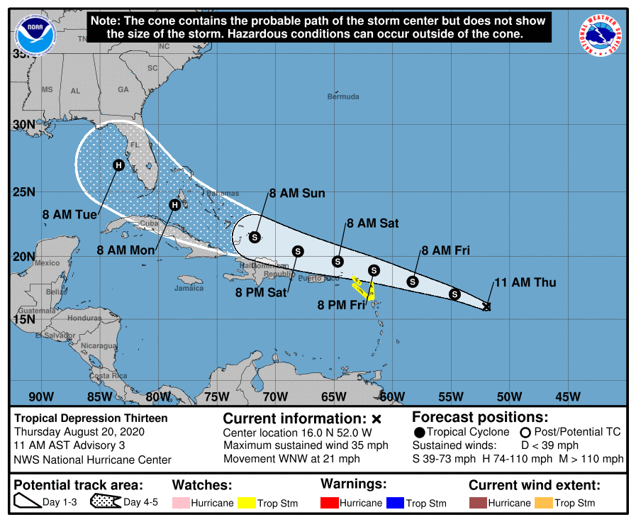
Tropical Depression Fourteen Discussion Number   1
NWS National Hurricane Center Miami FL       AL142020
1100 AM EDT Thu Aug 20 2020

Visible satellite images indicate that the area of disturbed
weather moving across the central Caribbean Sea has developed a
closed surface circulation, with the center embedded beneath
cellular convective cells and a large cirrus canopy.  Also,
convection has increased in organization, and TAFB and SAB have
given the system classification of T2.0/30 kt and T1.5/25 kt,
respectively.  Therefore, advisories are being initiated on
Tropical Depression Fourteen with maximum winds of 30 kt.  An
expected ASCAT pass later today and an Air Force Reserve Hurricane
Hunter mission scheduled for this afternoon should give us a better
handle on both the depression's center location and its maximum
winds.

The depression continues to move westward at a pretty good clip,
currently estimated to be on a heading of 280 degrees at 18 kt.
This motion is being driven by the western extent of the Bermuda
high, which currently noses into the northwestern Caribbean Sea.
However, a deep-layer trough over the Gulf of Mexico is expected to
become the main driver in the coming days, causing the cyclone to
slow down and turn rather suddenly toward the west-northwest and
northwest in the next 24-36 hours.  A general northwestward motion
should then continue until the end of the 5-day forecast period,
bringing the system across the Yucatan Peninsula Saturday night and
into the central and western Gulf of Mexico early next week.  Most
of the reliable track models are clustered close to one another,
and the official NHC track forecast is therefore very close to the
multi-model consensus aids, including the HCCA model.

Once the depression slows down during the next 24-36 hours,
environmental conditions appear ideal for strengthening.  The
magnitude of vertical shear is expected to be less than 10 kt for
at least the next 2 days, while the system will be moving over the
deep, warm waters of the northwestern Caribbean Sea, where sea
surface temperatures are 29-30 degrees Celsius.  Given these
conditions, some of the intensity guidance actually appears more
muted than I would have expected, and I have therefore elected to
closely follow the SHIPS and LGEM models, which are near the upper
end of the guidance envelope.  It is possible that the depression
could be near or at hurricane strength when it approaches the
Yucatan Peninsula of Mexico in 2-3 days.  Some weakening is
anticipated when the center moves over land, and then
re-strengthening is likely after it moves over the Gulf of Mexico.
There will be an increase in shear over the Gulf in 4-5 days, and
right now there is greater-than-normal uncertainty in how this will
affect the cyclone's intensity at that point.  For now, the
official forecast on days 4 and 5 shows a flat-lined intensity, and
this scenario lies a little above the ICON intensity consensus and
the HCCA model solution.

Key Messages:

1. Tropical Depression Fourteen is expected to strengthen over the
northwestern Caribbean Sea through Saturday, and it could produce
tropical-storm-force winds and heavy rainfall over portions of the
coast of Honduras and the Bay Islands beginning tonight through
Friday.  The system could be near or at hurricane strength when it
reaches the Yucatan Peninsula of Mexico late Saturday, and watches
could be required for a portion of that area later today.

2. The system is expected to move into the south-central Gulf
of Mexico as a tropical storm on Sunday.  Some strengthening is
anticipated while it moves northwestward over the western Gulf of
Mexico early next week, but it is too soon to know exactly how
strong it will get or the location and magnitude of impacts it
will produce along the central or northwestern Gulf Coast.
Interests in that area should continue monitoring the progress of
this system over the next few days.


Tropical Depression Thirteen Discussion Number   3
NWS National Hurricane Center Miami FL       AL132020
1100 AM AST Thu Aug 20 2020

The organization of the depression has not changed much overnight
or this morning.  An area of convection has persisted near the
estimated center, with some banding noted over the northwestern
portion of the circulation.  An earlier SSMIS overpass was very
helpful in locating the center of what appears to be a small
circulation.  A very recent ASCAT overpass has also revealed a
small circulation that is weak on the southeastern side, but with
winds near tropical storm strength to the north of the center.  The
ASCAT data along with subjective Dvorak classification from TAFB and
SAB support maintaining the 30-kt initial intensity.

The depression continues to move briskly west-northwestward or
290/18 kt.  The track forecast philosophy has not changed from
before.  A subtropical ridge over the central Atlantic is forecast
to build westward and strengthen over the next several days.  This
pattern is expected to keep the cyclone on a west-northwestward
heading throughout the forecast period.  The dynamical models
continue to agree on this overall scenario, but there some
differences in both forward speed and how close it gets to the
Greater Antilles.  In general, the models that indicate a stronger
cyclone favor a more northern track, while those which depicted a
weaker system are along the southern and faster side of the
envelope.  The latest consensus aids are little north of the
previous track, and the new NHC forecast lies between the HFIP
corrected consensus and the TVCA multi-model consensus.  This is
slightly north of the previous advisory, and not far from the GFS
ensemble mean.

The environment consisting of light to moderate vertical wind shear
is expected to allow for gradual strengthening over the next few
days, and the NHC forecast calls for the system to become a tropical
storm later today or tonight.  The upper-level wind pattern is
expected to remain favorable in the latter portion of the forecast
period, and if there is minimal land interaction, a faster rate of
strengthening is possible at that time. The NHC intensity foreast
now shows the system becoming a hurricane by 96 hours, but it is a
little lower than the consensus aids at days 4 and 5 due to
uncertainty in how much the system will interact with the Greater
Antilles.

Key Messages:

1. Tropical storm conditions are possible across portions of the
northern Leeward Islands by Friday night, and Tropical Storm Watches
have been issued for some of these islands.  Heavy rainfall is
likely across this area beginning late Friday.

2.  There is a risk of tropical storm conditions in the Virgin
Islands and Puerto Rico Friday night and Saturday and Tropical
Storm Watches could be required for these islands later today.
Interests there should closely monitor the progress of this system.

3.  The details of the long-range track and intensity forecasts are
more uncertain than usual since the system could move over portions
of the Greater Antilles this weekend.  However, this system could
bring some storm surge, rainfall and wind impacts to portions of
Hispaniola, Cuba, the Bahamas, and Florida this weekend and early
next week. Interests there should monitor this system's progress
and updates to the forecast over the next few days.


