


This is a developing situation. Please monitor local TV and radio for local updates. We will update Saturday evening and Sunday morning:
The NWS and the NOAA Storm Center have been predicting a severe weather threat for this weekend for at least 72 hours. The severe event this weekend begins today in Texas and continues tomorrow across the South. Hee is what we know today:
- Severe storms with possible tornados will fire up this afternoon in Texas. San Antonio, Austin and Houston are under the gun.
- This system will come in waves. The first overnight and into the morning with heavy rains for many. The duration of these heavy rains will have a direct effect on the severity of storms for many. If they clear out quickly and the heat of the day is allowed to de-stabilize the atmosphere, then the severe threat increases.
- Tornados, flash flooding, high winds are the 3 main threats.
- New Orleans, Baton Rouge, Jackson, Birmingham are just some of the municipalities that are to be aware of the threat of long tracking tornados. Especially with the second wave expected Easter afternoon
- A 3rd wave is expected overnight into early morning.
- 2″-6″ of rain are expected in 24 hours across many areas including Alabama, Tennessee, and Georgia.
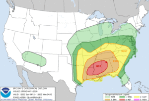
The official Saturday morning statement from the NWS and Storm Prediction Center:
Day 2 Convective Outlook
   NWS Storm Prediction Center Norman OK
   1259 AM CDT Sat Apr 11 2020

   Valid 121200Z - 131200Z

   ...THERE IS A MODERATE RISK OF SEVERE THUNDERSTORMS FOR
   CENTRAL/NORTHERN LOUISIANA...SOUTHEAST ARKANSAS...MUCH OF
   MISSISSIPPI...WESTERN/CENTRAL ALABAMA......

   ...SUMMARY...
   An outbreak of severe thunderstorms appears likely Sunday into
   Sunday night, with the greatest threat expected from Louisiana
   through much of the Southeast and Tennessee Valley. Strong
   tornadoes, potentially widespread damaging winds, and large hail are
   all possible.

   ...Synopsis...
   The ejecting shortwave trough initially over the southern High
   Plains on Sunday morning is forecast to move quickly eastward to the
   lower MS Valley by early evening, and then accelerate northeastward
   toward the Ohio Valley late Sunday night into Monday morning, as it
   becomes absorbed within an amplifying longwave trough that will
   encompass nearly all the CONUS by 12Z Monday. In conjunction with
   the ejecting trough, a broad surface low centered over the
   central/southern Plains on Sunday morning will move eastward to the
   mid-MS Valley by 00Z Monday, and then move northeastward and rapidly
   intensify into an intense cyclone over the lower Great Lakes by 12Z
   Monday. A warm front will surge northward ahead of the low across
   the lower MS Valley and Southeast, while a strong cold front will
   move southward through much of the Plains in the wake of the
   departing cyclone.

   ...East TX northeastward through much of the Southeast and TN
   Valley...
   One or more clusters of deep convection will likely be ongoing at
   12Z Sunday morning somewhere over east TX and potentially into
   portions of the lower MS Valley. The intensity and areal extent of
   any such clusters remain uncertain, but ample shear and instability
   will favor a threat of hail and damaging wind with any organized
   convection at the start of the period. Some tornado threat will also
   be present Sunday morning with any semi-discrete storms that begin
   to interact with the richer low-level moisture in the vicinity of
   the warm front. As this convection spreads northeastward,
   intensification is possible into portions of the ArkLAMiss region,
   with an increasing tornado threat in late morning/early afternoon
   with any surface-based storms, given rapidly increasing low-level
   moisture and shear. North of the warm front, evolution into a QLCS
   will be possible, with a corresponding risk of damaging wind into
   portions of the TN Valley.

   Meanwhile, further south, moderate to locally strong instability is
   forecast to develop along/south of the warm frontal position, which
   will be modulated by the impact of outflow from any early convection
   described above. Midlevel flow will increase to 70-100 kt as a
   south-southwesterly low-level jet intensifies into the 40-60 kt
   range. These wind profiles combined with ample instability (MLCAPE
   of 1500-3000 J/kg) will support the potential for intense
   supercells. Any surface-based initiation along and east of a
   pseudo-dryline moving into western LA by late afternoon could evolve
   into one or more long-tracked supercells capable of producing strong
   tornadoes, large hail, and damaging wind gusts. The extent of
   development within the warm sector remains somewhat uncertain, given
   the presence of a capping inversion and generally subtle foci for
   initiation.

   While the conditional risk of all severe hazards will be quite high
   if supercells develop, uncertainty remains regarding how convection
   will evolve from the morning into the afternoon. Any remnant outflow
   related to early convection will determine the northern extent of
   the higher-end tornado potential, and some guidance suggests the
   potential for elevated convection within a midlevel moist plume
   across the warm sector during the afternoon, which could either
   dampen the severe potential, or evolve into surface-based convection
   with a substantial severe threat. Given these factors, there is too
   much uncertainty to upgrade the ongoing outlook at this time.

   Evolution into more of QLCS is suggested by most guidance by Sunday
   evening, which would pose an increasing threat of widespread
   damaging winds and a few tornadoes across much of AL into
   western/central GA through the overnight hours. Higher wind
   probabilities may be needed in subsequent outlooks if confidence in
   this scenario grows.

   ...Central/southern Plains into the Ozark Plateau...
   While widespread convection to the southeast will likely limit
   transport of deeper Gulf moisture into the Plains/Ozarks, more
   modest moisture that was advected into the region on Saturday should
   remain in place ahead the advancing surface low and cold front
   Sunday afternoon. Steep lapse rates and cold midlevel temperatures
   associated with the primary shortwave will support moderate
   destabilization. Wind profiles will likely not favor classic
   supercells, with some backing of mid/upper-level flow expected, but
   effective shear will be supportive of organized structures. Large
   hail (potentially significant) will be the primary threat, with some
   wind potential if any upscale growth occurs. Wind profiles will not
   generally favor tornado potential, though robust updrafts
   interacting with locally enhanced vorticity near the surface cyclone
   could produce a tornado or two.

   ...TN Valley into the OH Valley -- Sunday night...
   Substantial uncertainty remains regarding the potential for
   destabilization from northern portions of the TN Valley into the OH
   Valley, due to the potential for widespread convection to the south
   of this area. However, rapidly strengthening wind fields in advance
   of the deepening cyclone will support the potential for damaging
   wind and perhaps a tornado risk by Sunday evening should even modest
   destabilization occur, as strong convection attempts to move in from
   the southwest in tandem with the deepening cyclone.

   ... Eastern Georgia into the Carolinas/Mid Atlantic...
   Substantial low-level moistening is expected over eastern GA into
   the Carolinas/Mid Atlantic through the period. There is a nonzero
   risk of organized convection along/north of the warm front during
   the day into the evening, which would pose some risk of locally
   damaging wind or perhaps a tornado, but confidence in this scenario
   is low at this time. A more likely scenario is for widespread
   upstream convection to evolve into multiple clusters or a QLCS and
   move into this region sometime early Monday morning. Intense wind
   profiles will support a risk of widespread damaging wind and a few
   tornadoes, given sufficient instability.

   The magnitude and coverage of the severe threat in this region will
   be determined in part by how fast organized convection approaches
   from the west. If convection accelerates and arrives faster that
   current guidance would indicate, then there is less time for
   low-level moistening and destabilization, and the magnitude and
   northward-extent of the threat may be limited. If convection does
   not arrive until very late in the period, then a more substantial
   severe threat could evolve. If some of the slower guidance turns out
   to be accurate, then the primary severe threat in this region may
   not come until the D3/Monday period. Probabilities may need to be
   increased in this area once the details come into better focus.


