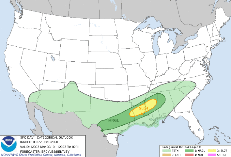
Many in the South woke up to rain this morning, many more in the South will see it by day’s end. Flash flooding will be a major concern for Mississippi and Alabama. Parts of Texas, Tennessee, Georgia, North Carolina and Louisiana will also see excessive rain withing embedded thunderstorms. Some storms are forecast severe with high winds and possible tornadoes through Monday night.
High winds and excessive rainfall the last 2 weeks male downed trees a concern also.
Wednesday-Thursday a second round of rain and severe storms is expected to arrive.
Rainfall totals this week will be 3 to 5 inches from eastern Texas northeastward to northern Louisiana, southern Arkansas, northern and central Mississippi, Tennessee, northern and central Alabama, northern Georgia, southeastern Kentucky and the western Carolinas. Some areas could see localized totals up to 8 inches.
Besides the threat of flash flooding, river flooding this week is now a concern. We will keep you up to date, but monitoring local stations is advised.
Several locations across the South have picked up more than a foot of rainfall since the start of the year. Jackson, Mississippi, has measured 15.19 inches, which is 9 inches above average, and as a result, it is experiencing the second-wettest start to the year on record, according to the Southeast Regional Climate Center.
From the NWS :
There is a Slight Risk for severe thunderstorms from eastern Texas to central Mississippi through Tuesday morning… Much of the area from the south-central U.S. to the Southern and Central Appalachian region will have scattered to widespread rain through at least midweek. Pooling moisture from the Gulf of Mexico will fuel nearly continuous convection over this region as cold front slowly progresses across the central U.S. The Storm Prediction Center has identified the area from eastern Texas to central Mississippi as having a Slight Risk for sever thunderstorm development. This environment will also be conducive for periods of moderate to heavy rainfall, especially over areas that have had several inches of rain in the past 1-2 weeks. With soils near saturation and multi-day areal averages of 3 to 7 inches inches forecast, there will be an enhanced risk for widespread flooding concerns from eastern Texas to central West Virginia. WPC has issued a High Risk for excessive rainfall for northern Mississippi and Alabama valid through Tuesday morning. A broad Slight Risk area has been issued for much of the Gulf states through Wednesday morning and areas northward to the southern Ohio Valley through Thursday morning. Many streams may flood and will potentially affect larger rivers, so please continue to monitor the latest forecast. Do not drive through flooded areas.
254 AM EST Mon Feb 10 2020

Valid 12Z Mon Feb 10 2020 - 12Z Wed Feb 12 2020

...A High Risk for excessive rainfall has been issued for the Gulf states.
Moderate to heavy rain is expected from the Lower Mississippi Valley to
the Central and Southern Appalachian region; which will likely leading to
localized flooding from eastern Texas to West Virginia.
THERE IS A SLIGHT RISK OF SEVERE THUNDERSTORMS ACROSS PARTS OF
   THE LOWER MISSISSIPPI VALLEY AND CENTRAL GULF COAST STATES...

   ...SUMMARY...
   Severe storms will be possible today from the southern Plains
   east-northeastward into the central Gulf Coast States. The greatest
   severe threat will be in parts of the Lower Mississippi Valley where
   wind damage and a couple tornadoes may occur.

   ...Southern Plains/Lower Mississippi Valley/Central Gulf Coast
   States...
   West to southwest mid-level flow will be in place today across much
   of the central and eastern U.S. Several subtle pertabations are
   forecast to move east-northeastward across the Gulf Coast States. At
   the surface, a cold front will move southeastward across the Texas
   Coast Plains, Arklatex and Tennessee Valley. The front is expected
   to slow down, becoming quasi-stationary across northern Louisiana
   and north-central Mississippi. A large area of precipitation will be
   ongoing along much of the front this morning. South of this band of
   precipitation, a moist airmass will be in place with surface
   dewpoints gradually increasing into the mid 60s F. In response, weak
   to moderate instability should develop by mid to late afternoon.
   Thunderstorms that form along the southern edge of the band of
   precipitation will have access to this moist airmass. The
   instability combined with strong deep-layer shear will create
   conditions favorable for severe storms.

   Forecast soundings in northern Louisiana for 00Z/Tuesday have 0-3 km
   storm relative helicities in the 350 to 400 m2/s2 suggesting a
   tornado threat will exist with supercells that develop. The tornado
   threat is forecast to be greatest during the early to mid evening as
   a 40 to 50 kt low-level jet strengthens across the lower Mississippi
   Valley. Wind damage will also be possible with supercells and/or
   short line segments. The threat is expected to persist through much
   of the evening. A hail and isolated wind damage threat will also be
   possible with cells that form along the front across parts of
   south-central and southeast Texas but weaker instability should keep
   the severe threat marginal there.


