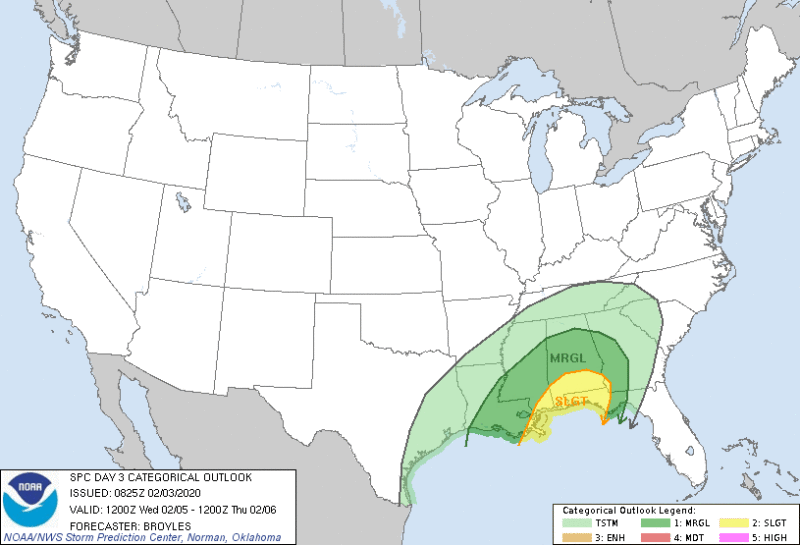
A multi-day severe threat is probable throughout most of the South this week beginning Tuesday. Here is what we know from the National Weather Service. Please be weather aware , even though it is February. Watch or listen to local channels for updates.
- Severe thunderstorms will threaten the South Tuesday through Thursday.
- Damaging wind gusts, hail and isolated tornadoes are possible.
- Heavy rain could cause flooding in the South and Ohio Valley.
...THERE IS A MARGINAL RISK OF SEVERE THUNDERSTORMS FROM EAST TX
   THROUGH THE MID-SOUTH...

   ...SUMMARY...
   Isolated severe thunderstorms will be possible on Tuesday from East
   Texas across the Mid-South. Damaging wind gusts and hail will be the
   primary threats.
...THERE IS A SLIGHT RISK OF SEVERE THUNDERSTORMS ACROSS PARTS OF
   THE CENTRAL GULF COAST REGION...

   ...SUMMARY...
   Scattered thunderstorms associated with wind damage and hail will be
   possible Wednesday night across parts of the central Gulf Coast
   region.

   ...Southeast...
   An upper-level trough is forecast to move eastward across the High
   Plains on Wednesday as southwest mid-level flow remains in place
   from the Southern Plains to the Atlantic Seaboard. At the surface, a
   cold front is forecast to advance southeastward into the Southeast
   as a moist airmass remains in place ahead of the front. Thunderstorm
   development will be possible during the day along and ahead of the
   front from Louisiana east-northeastward to central Alabama.
   Relatively weak instability should keep any severe threat marginal
   during the day.

   By Wednesday evening, model forecasts suggest that a subtle
   shortwave trough will move quickly northeastward from the western
   Gulf of Mexico to the central Gulf Coast. In response to lift
   associated with the shortwave trough and increasing low-level warm
   advection, convection should increase in coverage across the
   north-central Gulf of Mexico. These thunderstorms are forecast to
   move northeastward during the overnight period, reaching the central
   Gulf Coast around 06Z.
...DISCUSSION...
   ...Thursday/Day 4...
   An upper-level trough is forecast to move eastward across the
   central U.S. on Thursday as a powerful 100 to 120 kt mid-level jet
   moves across the Southeast. At the surface, a cold front is forecast
   to advance southeastward across the central Gulf Coast States on
   Thursday. A moist airmass should be in place ahead of the front from
   Florida north-northeastward into the Carolinas. A line of strong
   thunderstorms is expected to develop by midday from the Florida
   Panhandle to the Carolinas with this feature moving eastward across
   the region during the afternoon. The mid-level jet will be
   associated with strong deep-layer shear and a band of enhanced
   large-scale ascent. This should support squall line development
   Thursday afternoon. Wind damage, hail and perhaps an isolated
   tornado threat will be possible along or ahead of the line.


