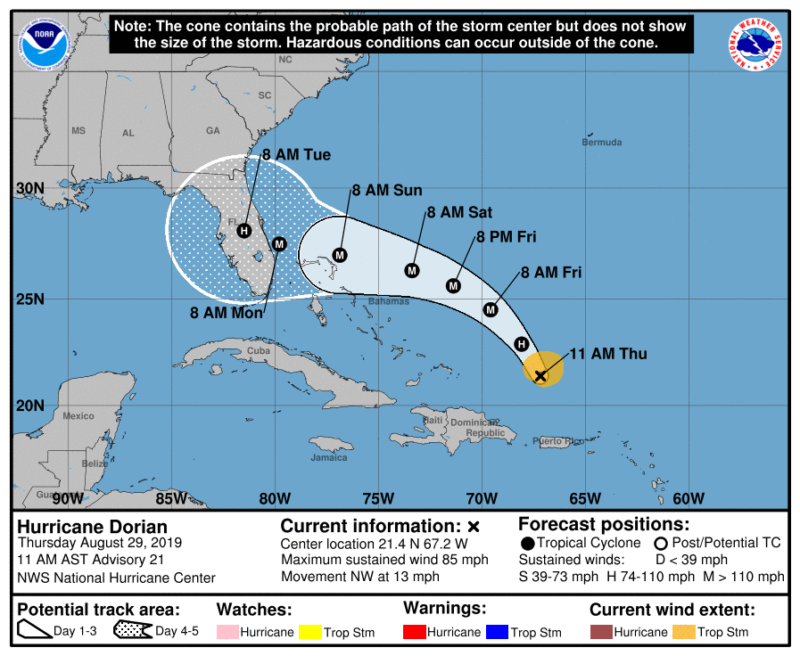
Governor Ron DeSantis issued Executive Order 19-189, declaring a state of emergency for counties in the path of Hurricane Dorian. The Governor is urging all Floridians on the East Coast to prepare for impacts, as the latest forecasts from the National Hurricane Center project Hurricane Dorian will make landfall on Florida’s East Coast as a major hurricane.
By declaring a state of emergency, Governor DeSantis is ensuring that state and local governments have ample time, resources and flexibility to prepare. The State Emergency Operations Center will activate to a Level 2 on Thursday morning, enhancing the coordination between federal, state and local emergency management agencies.
Early signs point to a west coast event also as Dorian could cross the state and roll out into the Gulf.
Latest From NWS at 10:00 p.m. CST :
Please note we will be updating as the storm approaches the Florida coast as often as possible. Updates will be only from the NWS . Today we are updating full reports at 4:00 p.m.CST and 10:00 p.m. CST ( unless NHC changes this) . Tomorrow thru the end or weakening of this event we will be updating as the NHC Center updates
Live cams will be put on our site Thursday. Like us on Facebook to see updates as we publish them.
Vote For Your Favorite College Football Tradition Here
Hurricane Dorian Advisory Number  21
NWS National Hurricane Center Miami FL       AL052019
1100 AM AST Thu Aug 29 2019

...DORIAN MOVING NORTHWESTWARD...
...EXPECTED TO STRENGTHEN DURING THE NEXT COUPLE OF DAYS...


SUMMARY OF 1100 AM AST...1500 UTC...INFORMATION
-----------------------------------------------
LOCATION...21.4N 67.2W
ABOUT 220 MI...355 KM NNW OF SAN JUAN PUERTO RICO
ABOUT 370 MI...600 KM E OF THE SOUTHEASTERN BAHAMAS
MAXIMUM SUSTAINED WINDS...85 MPH...140 KM/H
PRESENT MOVEMENT...NW OR 325 DEGREES AT 13 MPH...20 KM/H
MINIMUM CENTRAL PRESSURE...986 MB...29.12 INCHES


WATCHES AND WARNINGS
--------------------
There are no coastal watches or warnings in effect.

Interests in the northwestern and central Bahamas should monitor the
progress of Dorian.


DISCUSSION AND OUTLOOK
----------------------
At 1100 AM AST (1500 UTC), the center of Hurricane Dorian was
located near latitude 21.4 North, longitude 67.2 West. Dorian is
moving toward the northwest near 13 mph (20 km/h), and this general
motion is expected to continue through Friday.  A west-northwestward
motion is forecast to begin by Friday night and continue into the
weekend.  On this track, Dorian should move over the Atlantic well
east of the southeastern and central Bahamas today and on Friday,
approach the northwestern Bahamas Saturday, and move near or over
portions of the northwest Bahamas on Sunday.

Maximum sustained winds are near 85 mph (140 km/h) with higher
gusts.  Strengthening is forecast during the next few days, and
Dorian is expected to become a major hurricane on Friday, and remain
an extremely dangerous hurricane through the weekend.

Hurricane-force winds extend outward up to 15 miles (30 km) from the
center and tropical-storm-force winds extend outward up to 90 miles
(150 km).

The minimum central pressure based on data from a NOAA Hurricane
Hunter aircraft is 986 mb (29.12 inches).


HAZARDS AFFECTING LAND
----------------------
RAINFALL:  Dorian is expected to produce the following rainfall
accumulations this weekend into early next week:

The central Bahamas...1 to 2 inches, isolated 4 inches.
The northwestern Bahamas...3 to 6 inches, isolated 8 inches.
Coastal sections of the Southeast United States...4 to 8 inches,
isolated 12 inches.

This rainfall may cause life-threatening flash floods.

SURF:  Swells around the U.S. and British Virgin Islands and
Puerto Rico should gradually diminish today.  Swells are likely to
begin affecting the east-facing shores of the Bahamas and the
southeastern United States coast during the next few days.  These
swells are likely to cause life-threatening surf and rip current
conditions.  Please consult products from your local weather office.


NEXT ADVISORY
-------------
Next complete advisory at 500 PM AST.
1. The risk of life-threatening storm surge and hurricane-force
winds this weekend continues to increase in the northwestern
Bahamas, and hurricane watches could be issued there tonight or
Friday.  Residents should have their hurricane plan in place and
listen to advice given by local emergency officials.

2. There is an increasing likelihood of life-threatening storm surge
along portions of the Florida east coast late this weekend or early
next week, although it is too soon to determine where the highest
storm surge will occur. Residents should have their hurricane plan
in place, know if they are in a hurricane evacuation zone, and
listen to advice given by local emergency officials.

3. The risk of devastating hurricane-force winds along the Florida
east coast and peninsula late this weekend and early next week
continues to increase, although it is too soon to determine where
the strongest winds will occur.

4. Regardless of the exact track of Dorian, heavy rains are expected
to occur over portions of the Bahamas, Florida, and elsewhere in the
southeastern United States this weekend and into the middle of next
week.


