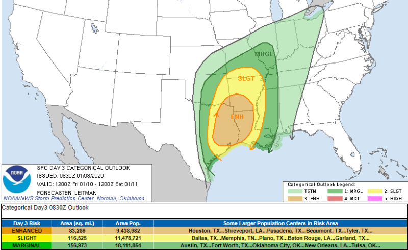
The NOAA Storm Prediction Center has growing certainty that this weekend will be bumpy for the South, beginning Friday afternoon. We will begin updates Friday morning, but, y’all in Texas, Arkansas, Louisiana, and West Tennessee need to be alert, especially in the evening hours. The severe threat includes straight line winds, hail, and isolated super cell tornadoes. Heavy rains over already saturated ground will lead to flash flooding and river flooding is possible in Arkansas , Missouri, and parts of Tennessee . 2″-6″ of rain are possible across the region.
The Friday scenario is below. It’s still a bit early for Saturday, but Alabama, Mississippi, and Tennessee should be on alert and we will update. A Saturday outlook can be heard here from Meteorologist Eddie Holmes.
From NOAA on Friday’s Storm Predictions:
0230 AM CST Wed Jan 08 2020

   Valid 101200Z - 111200Z

   ...THERE IS AN ENHANCED RISK OF SEVERE THUNDERSTORMS ACROSS PORTIONS
   OF FAR SOUTHEAST OK...EASTERN TX...NORTHERN AND SOUTHWEST LA AND
   SOUTHERN AR...

   ...SUMMARY...
   Severe thunderstorms are possible Friday afternoon into early
   Saturday morning across portions of the Arklatex into the lower
   Mississippi Valley vicinity. Damaging wind gusts and tornadoes will
   be the main threats with these storms.

   ...Synopsis...

   A volatile weather pattern continues to be apparent for Friday from
   eastern TX/OK into the lower MS Valley. An intense mid/upper
   shortwave trough over the southern Rockies into northern Mexico will
   intensify as it shifts east into the southern Plains through the end
   of the period. Most guidance shows a 100+ kt 500 mb jet streak
   spreading across eastern OK/TX after 00z, with a 60+ kt
   south/southwesterly low level jet developing over the
   Arklatex/Sabine River vicinity by 00z. Guidance varies some in the
   development of a surface low, located somewhere from north TX to
   northern OK Friday morning. The low will deepen as it shifts
   east/northeast across AR to near the MO Bootheel vicinity by
   Saturday morning.

   While the evolution of the surface low remains a bit uncertain,
   strong south/southeasterly low level flow ahead of the low and its
   associated cold front, will bring rich Gulf moisture northward
   across eastern OK/TX and the lower MS Valley. Upper 60s F to low 70s
   F dewpoints over eastern and coastal TX will spread eastward across
   LA/southern AR and into MS and southwest AL by 12z Saturday. Atop
   this anomalously moist boundary layer, steep midlevel lapse rates
   courtesy of an EML spreading east/northeast from the Mexican Plateau
   will result in pockets of MLCAPE from 750-1500 J/kg from eastern TX
   into LA and adjacent portions of AR/MS where stronger heating is
   expected. Further north, where temperatures and dewpoints will be
   lower, instability will quickly diminish to less than 500 J/kg into
   the mid-MS Valley. Mixed convective mode is likely, with a QLCS
   developing in the vicinity of the surface cold front by late
   afternoon across OK/north TX. Intense shear will aid in damaging
   wind potential and very moist low levels, combined with backed low
   level flow/strong SRH, will support mesovortex development along the
   line. The QLCS will develop east/northeast through the overnight
   hours.

   Additionally concerning is any convection that develops across the
   warm sector ahead of the front/QLCS. Guidance continues to indicate
   that more discrete warm sector development is possible, across parts
   of eastern TX into LA. Supercells capable of all severe hazards,
   some possibly significant, appear most probable across this area
   from late afternoon into the overnight hours.


