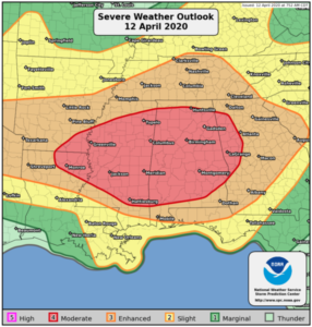
 An outbreak of severe thunderstorms is likely today into tonight, with the greatest threat expected from Louisiana through much of the Southeast and Tennessee Valley. Strong tornadoes will be most probable during the day from northeast Louisiana across Mississippi and Alabama. Later in the afternoon and evening, another round of severe storms with widespread damaging winds, large hail and tornadoes is expected across Arkansas into western Tennessee and western Kentucky by early tonight. The severe-weather threat will persist into tonight and early Monday across Georgia and the western Carolinas.
ZCZC SPCPWOSPC ALL
   WOUS40 KWNS 121314
   ALZ000-ARZ000-GAZ000-LAZ000-MSZ000-121800-

   PUBLIC SEVERE WEATHER OUTLOOK
   NWS STORM PREDICTION CENTER NORMAN OK
   0814 AM CDT SUN APR 12 2020

   ...Severe thunderstorms expected over parts of the Southeast U.S.
   today and tonight...

   * LOCATIONS...
     Alabama
     Much of Mississippi
     Western Georgia
     Northeast Louisiana
     Southeast Arkansas

   * HAZARDS...
     Several tornadoes, a few intense
     Widespread damaging winds
     Scattered large hail, some baseball size

   * SUMMARY...
     An outbreak of severe thunderstorms is likely today into
     tonight, with the greatest threat expected from Louisiana
     through much of the Southeast and Tennessee Valley. Strong
     tornadoes will be most probable during the day from northeast
     Louisiana across Mississippi and Alabama. Later in the afternoon
     and evening, another round of severe storms with widespread
     damaging winds, large hail and tornadoes is expected across
     Arkansas into western Tennessee and western Kentucky by early
     tonight. The severe-weather threat will persist into tonight and
     early Monday across Georgia and the western Carolinas.

   Preparedness actions...

   Review your severe weather safety procedures for the possibility
   of dangerous weather today. Stay tuned to NOAA Weather Radio,
   weather.gov, or other media for watches and warnings. A tornado
   watch means that conditions are favorable for tornadoes to form
   during the next several hours. If a tornado warning is issued for
   your area, move to a place of safety, ideally in a basement or
   interior room on the lowest floor of a sturdy building.

Day 1 Convective Outlook
   NWS Storm Prediction Center Norman OK
   0752 AM CDT Sun Apr 12 2020

   Valid 121300Z - 131200Z

   ...THERE IS A MODERATE RISK OF SEVERE THUNDERSTORMS TODAY INTO
   TONIGHT FROM THE ARK-LA-MISS EASTWARD INTO AL AND WESTERN GA...

   ...SUMMARY...
   An outbreak of severe thunderstorms is likely today into tonight,
   with the greatest threat expected from Mississippi across Alabama
   into western Georgia. Strong tornadoes, widespread damaging winds,
   and large hail are all possible.

   ...Synopsis...
   A complex forecast today with multiple scenarios possible across a
   broad area from the lower MS Valley into the TN/OH Valleys and the
   Southeast.  A midlevel trough near the TX Big Bend this morning will
   accelerate east-northeastward to the Ark-La-Miss by this evening and
   the Appalachians by the end of the period, in response to continued
   amplification of a large-scale trough over the north central CONUS.
   At the surface, a cyclone will move across OK today and develop
   eastward to AR by this evening, followed by substantial deepening as
   the cyclone moves northeastward to the OH Valley/Great Lakes
   overnight.  A moist/unstable warm sector will surge northward across
   LA/MS/AL/GA today, setting the stage for severe storms with the
   ejecting shortwave trough and deepening cyclone through tonight.
   Several scenarios are possible within the overall outlook area, with
   substantial uncertainty related to early/ongoing convection now in
   TX.

   ...Northeast TX to northern MS/AL and TN this afternoon...
   An ongoing cluster of severe storms continues to move
   east-northeastward into east central and northeast TX this morning,
   in association with a lead shortwave trough.  All hazards will be
   possible with this cluster which will include a mixed convective
   mode of supercells and bowing segments.  Low-level moisture will
   surge northward today across LA/MS/AL in response to the deepening
   cyclone moving from OK to AR.  The main question through mid
   afternoon will be whether or not surface destabilization will keep
   pace with the initial cluster.  If warming/moistening can occur
   quickly enough, the chance for surface-based storms on the southern
   flank will increase.  This may occur coincident with an environment
   characterized by moderate buoyancy (MLCAPE of 1500-2500 J/kg), very
   strong low-level shear (0-1 km SRH of 400-500 m2/s2) as the
   low-level jet strengthens over LA/MS, and effective bulk shear in
   excess of 70 kt.  This environment will favor embedded supercells
   capable of producing strong tornadoes and damaging winds.  Again,
   the main questions in this corridor through this afternoon will be
   the degree of organization of the late morning-early afternoon
   convection, and its phasing with the surface warm front.

   ...MS/AL/GA/Carolinas late this afternoon through tonight...
   To the south of the initial storm cluster crossing northern
   MS/AL/TN, a separate pre-frontal band of convection is expected to
   develop by late afternoon from southern MS into western/central AL.
   This convection will be well east the synoptic cold front, in an
   environment with surface-based buoyancy and very strong vertical
   shear.  A broken band with embedded supercells appears likely to
   persist well into the overnight hours, with an associated threat for
   strong tornadoes and damaging winds.  The pre-frontal convection
   should reach the western Carolinas by 09-12z.

   ...Red River Valley this afternoon to the OH Valley overnight...
   An arc of convection will likely form this afternoon near the
   surface low in southeast OK, and within the left-exit region of the
   mid-upper jet.  This convection will subsequently spread eastward
   and northeastward into AR through late afternoon/evening.  The
   northward extent of destabilization in AR/western TN this
   afternoon/evening will depend largely on the intensity and extent of
   the early afternoon convection moving from LA into northern MS.
   Still, steep midlevel lapse rates with the ejecting midlevel wave
   and strong deep-layer vertical shear will favor fast-moving
   supercells and line segments capable of producing large hail and
   damaging winds.  Similar to AR this afternoon, the northeast extent
   of the damaging wind and tornado threat into tonight will depend
   largely on how widespread/organized the convection is across
   northern MS/AL this afternoon/evening, and the degree of low-level
   recovery in the wake of that convection.


