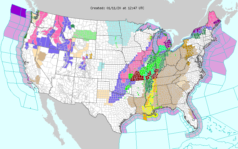
It was a long night for many in the South as severe weather wreaked havoc in many states. Today the threat moves through Louisiana, Tennessee, Alabama, Mississippi, Georgia, Kentucky and the Florida panhandle.
Wind advisories, severe thunderstorms with possible hail and flooding are concerns in these states. Missouri and Oklahoma see an ice and snow event making travel dangerous.
What we know so far:
- 3 dead in Louisiana from possible tornadoes
- Missouri drivers are asked to stay off the roads today
- Over 200,000 without power at the writing of this article, most in Texas from high winds
- Flooding is a definitive danger today
- Winds could gust over 70 mph in the Appalachians
From the NWS:
259 AM EST Sat Jan 11 2020 Valid 12Z Sat Jan 11 2020 – 12Z Mon Jan 13 2020
…Heavy snow and rain/freezing rain over parts of the Great Lakes into parts of Northern Maine….
…There is an enhanced risk of severe thunderstorms over parts of the Central Gulf Coast and slight risk of excessive rainfall over parts of the Lower/Middle Mississippi Valley into Western Ohio Valley and the Great Lakes…
…Temperatures will be 10 to 35 degrees above average over the Eastern Ohio Valley/Tennessee Valley into the Northeast… …
Heavy snow will continue over the higher elevations of the Northwest…
A potent winter storm will bring multiple weather hazards to much of the Great Lakes/Middle Mississippi Valley and portions of the Northeast. Severe thunderstorms, heavy rain and flash flooding will impact a vast portion of the Central Gulf Coast/Lower Mississippi Valley into the Great Lakes. Snow fall of up to one foot over parts of the Great Lakes downwind from Lake Huron with six to eight inches over parts of Wisconsin off of Lake Michigan. A mix of rain, freezing rain, sleet and snow is expected from the Middle Mississippi Valley to the Great Lakes and into Northern Maine. Ice accumulations of 0.25 to 0.50 inches over Michigan and Northern Maine.
Heavy rain in the range of 1 to 3+ inches is expected from the Tennessee Valley northeastward to the Great Lakes. Due to the slow progression of this system, storm motion will be slow and expected to track over the sames area. This will become become problematic as soils become saturated. A slight risk of excessive rainfall is forecast over parts of Tennessee Valley/Lower Mississippi Valley northeastward to the Western Ohio Valley and parts of the Great Lakes. The rain will produce scattered flash flooding that will be mainly localized. The most vulnerable area will be urban areas, roads, and small streams with isolated significant flash flooding possible.
Additionally, the Storm Prediction Center has forecast a Enhanced Risk of severe weather for parts of the Central Gulf Coast/Lower Mississippi Valley and Tennessee Valley. A stark temperature gradient will setup over the country thanks to the strong front over the eastern third of the country. In the warm sector ahead of the front, daily temperatures will average 10 to 35 degrees warmer than typical early January readings. Numerous records are expected to be broken from the Ohio and Tennessee Valleys into the Northeast.
The Pacific Northwest will have another low pressure system approach the region on Sunday, which will amplify the precipitation. Moderate to heavy snow will continue over the Intermountain West and Northern/Central Rockies through Monday. Snow accumulations may very well reach or exceed 2 feet in the highest peaks of the Cascades, around 1 foot elsewhere. The snow levels will drop down to the coast on Sunday into Monday over Washington and Oregon.


