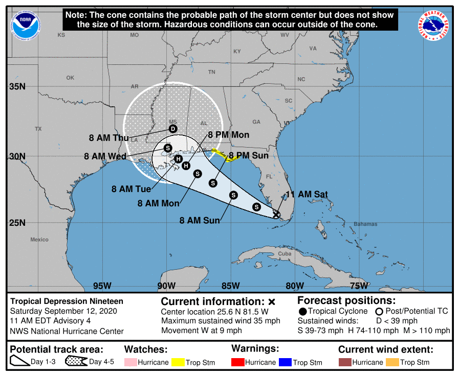
TD 19 is expected to drop lots of rain on Florida today and when it hits the Gulf rapidly become a hurricane. We will be monitoring this potentially dangerous storm and will update as needed. The latest from the National Hurricane Center:
Tropical Depression Nineteen Discussion Number   4
NWS National Hurricane Center Miami FL       AL192020
1100 AM EDT Sat Sep 12 2020

The tropical cyclone's cloud pattern has exhibited little change
on satellite imagery over the past several hours, although recently
the Miami radar shows better-defined banding features over the
southern portion of the circulation.  The current intensity
estimate remains at 30 kt for now, which is consistent with surface
observations over the extreme southern Florida peninsula.  An Air
Force Hurricane Hunter aircraft is scheduled to investigate the
system in a few hours, which should provide a better estimate of
the cyclone's intensity.  Since the system will be traversing very
warm waters and through a moist air mass with moderate vertical
shear for the next few days, steady strengthening is anticipated.
The cyclone will likely become a hurricane in 2-3 days, although
an increase in vertical shear could slow the rate of
intensification over the northern Gulf of Mexico.  The official
forecast intensity around 72 hours is very close to that shown by
the simple and corrected model consensus predictions.

The depression has been moving a little north of west, or about
280/8 kt.  A west-northwestward or northwestward motion is expected
for the next day or two, along the southwestern periphery of a
mid-level high pressure system centered just east of the
mid-Atlantic coast.  This high is forecast to weaken within 2-3
days which should lead to a slowing of the forward motion by
Monday.  The forward speed is likely to remain slow through 96
hours, although a high that is predicted to build over the Florida
peninsula in 4-5 days should push the system across the coastline
before the end of the forecast period.  The official track forecast
is close to the corrected consensus track prediction, HCCA, which
has been a reliable performer so far.

Users are reminded to not to focus on the exact details of the
track or intensity forecast as the average NHC track error at 96 h
is around 150 miles and the average intensity error is around
15 mph.  In addition, winds, storm surge, and rainfall hazards will
extend far from the center.

KEY MESSAGES:

1. The depression is forecast to strengthen to a hurricane early
next week as it moves across the northeastern Gulf of Mexico, and
there is an increasing risk of life-threatening storm surge and
dangerous hurricane-force winds from southeastern Louisiana to the
Alabama coast. Residents in these areas should closely monitor the
progress of this system and updates to the forecast, as Storm Surge
and Hurricane watches will likely be issued later today.

2. The depression is expected to produce flash flooding across
portions of southern Florida and prolong existing minor river
flooding across central Florida through Sunday. Flash, urban, and
minor to isolated moderate river flooding is likely across portions
of the central Gulf Coast Sunday through Tuesday.

3. Tropical storm conditions are possible by Sunday night in
portions of the Florida Panhandle, where a Tropical Storm Watch is
in effect.  Wind gusts to tropical-storm force could occur over
portions of the southern Florida Peninsula today.


FORECAST POSITIONS AND MAX WINDS

INIT  12/1500Z 25.6N  81.5W   30 KT  35 MPH
 12H  13/0000Z 26.2N  83.0W   35 KT  40 MPH
 24H  13/1200Z 27.1N  84.8W   40 KT  45 MPH
 36H  14/0000Z 28.0N  86.4W   50 KT  60 MPH
 48H  14/1200Z 28.7N  87.6W   60 KT  70 MPH
 60H  15/0000Z 29.3N  88.5W   65 KT  75 MPH
 72H  15/1200Z 29.8N  89.1W   70 KT  80 MPH
 96H  16/1200Z 30.6N  89.9W   55 KT  65 MPH...INLAND
120H  17/1200Z 32.0N  89.5W   30 KT  35 MPH...INLAND


