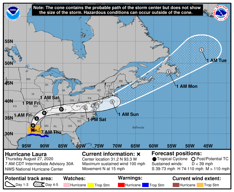
Laura made landfall early this morning. At the writing of this article she is a Cat 2 hurricane well inland.
The entire states of Louisiana and Arkansas should be weather aware today as torrential rains and winds will wreak havoc on both.
Outgoing bands from the storm have launched multiple tornado watches in many states
Flash Flooding will be a concern for many as the storm weakens to a depression and makes a hard right turn over Kentucky and Tennessee. It is expected to exit the East coast and re-strengthen to a tropical storm.
For Live stream coverage click here
Hurricane Laura Discussion Number  30
NWS National Hurricane Center Miami FL       AL132020
400 AM CDT Thu Aug 27 2020

Laura made landfall near Cameron, Louisiana, around 0600 UTC (1 am
CDT) with maximum sustained winds of 130 kt, which is near the high
end of category 4 status.  At the time of landfall, Laura was
a ferocious looking hurricane with a clear circular eye, an intense
eyewall, and tightly-coiled surrounding spiral bands.  Since the
powerful hurricane has been inland for a few hours, there has been
some decrease in winds, and the estimated initial wind speed based
on Doppler radar data, surface observations, and guidance from an
inland decay model is 105 kt.

The hurricane is now moving northward with the initial motion
estimated to be 355/13 kt. Laura is expected to continue moving
northward through tonight, which should take the core of the system
across Louisiana and Arkansas.  After that, Laura will likely
become embedded in the mid-latitude westerlies, and the much
weaker cyclone is forecast to move quickly east-northeastward
across the southeast U.S. and the mid-Atlantic states on Friday and
Saturday.  By late in the weekend and early next week, Laura,
or its extratropical remnants, should accelerate northeastward
across the western Atlantic.

Now that Laura is inland, rapid weakening is forecast and it
will likely become a tropical storm later today and a tropical
depression on Friday. It should be noted that strong hurricanes
like Laura are not just coastal events. Even though Laura's
highest winds will decrease quickly as it treks inland, significant
impacts from heavy rains and strong wind gusts are likely through
at least tonight across portions of Louisiana and Arkansas.  Some
strengthening as an extratropical cyclone is expected when the
storm moves over the Atlantic waters late this weekend and early
next week.

Key Messages:

1.  Unsurvivable storm surge with large and destructive waves will
cause catastrophic damage from Sea Rim State Park, Texas, to
Intracoastal City, Louisiana, including Calcasieu and Sabine Lakes.
This surge could penetrate up to 40 miles inland from the immediate
coastline, and flood waters will not fully recede for several days
after the storm.

2. Hurricane-force winds will continue this morning in portions of
the hurricane warning area, with catastrophic wind damage expected
near Laura's eyewall. Hurricane-force winds and widespread damaging
wind gusts will continue to spread well inland into portions of
extreme eastern Texas and western Louisiana through the day.

3. Widespread flash flooding along small streams, urban areas, and
roadways is expected across portions of Louisiana, Mississippi, and
Arkansas.  This will also lead to minor to moderate freshwater river
flooding.  The heavy rainfall threat and flash and urban flooding
potential will spread northeastward into the middle-Mississippi,
lower Ohio, Tennessee Valley, and Mid-Atlantic States Friday and
Saturday.

FORECAST POSITIONS AND MAX WINDS

INIT  27/0900Z 30.5N  93.4W  105 KT 120 MPH...INLAND
 12H  27/1800Z 32.6N  93.2W   65 KT  75 MPH...INLAND
 24H  28/0600Z 34.8N  92.2W   40 KT  45 MPH...INLAND
 36H  28/1800Z 36.5N  90.1W   30 KT  35 MPH...INLAND
 48H  29/0600Z 37.6N  85.4W   25 KT  30 MPH...INLAND
 60H  29/1800Z 38.2N  78.9W   30 KT  35 MPH...POST-TROP/INLAND
 72H  30/0600Z 39.8N  71.4W   40 KT  45 MPH...POST-TROP/EXTRATROP
 96H  31/0600Z 47.9N  55.9W   45 KT  50 MPH...POST-TROP/EXTRATROP
120H  01/0600Z 53.1N  46.8W   45 KT  50 MPH...POST-TROP/EXTRATROP


